
This is the second article in the series in which we are taking a journey through time on the historic waters of the Conestoga River. In the first article, I covered the conditions of the Conestoga prior to European settlement. We looked at how the Conestoga watershed looked very different than it does today. And we looked briefly at some of the early inhabitants of the area and how the river provided their sustenance.
In this installment, we will cover the colonial settlement era. We will look at how those settlers utilized the resources of the river for their sustenance and how farming and industry developed along the waterway, providing great prosperity to its new inhabitants.
Fur Trade
During the seventeenth century continuing into the eighteenth, the fur trade was big business among the Swedish, Dutch, French, and English traders. Many people wanted to get in on the action. There was intense competition between the governors of New York, Pennsylvania, and Maryland, each wanting to keep their ports busy.
The fur traders were an adventurous lot, rugged outdoorsmen who spent half their time bartering with the Natives in the wilderness and the other half bartering with the European settlers who wanted their goods. In many cases, the first white people with whom the natives came into close contact were the fur traders. The natives’ impression of white people was often formed by these encounters, for better or worse. During their work, the traders often learned the native languages and, in some cases, married native women. This made the traders valuable as interpreters when the colonial governments needed to hold conferences with the native tribes.
Two of these early traders who set up shop along the Conestoga were the Quaker Brothers, Edmund and John Cartlidge. Their trading post was at the mouth of the Conestoga, near the Susquehanna. The brothers got into some trouble in 1722 when they murdered a Seneca Indian. They were arrested and jailed in Philadelphia until they were eventually released at the urging of the Iroquois leadership.
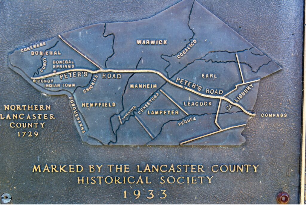
Some other prominent fur traders in the area were Martin Chartier, who had a trading post at the mouth of the Pequea Creek and Ann Letort with her son James. Anne’s name is preserved in the village of Letort in Manor Township. Another famous French trader was Peter Bezaillion. Peter and his brother Richard operated a trading post near the mouth of the Conoy creek in 1721. He built a wagon road from this trading post on the Susquehanna to his headquarters in Compass. This road, called “Peter’s Road”, formed the northern boundaries of Manheim and Upper Leacock Townships. The road forded the Conestoga at the point where those two townships meet, just below the conjunction with the Cocalico Creek.
The Indians supplied the traders with animal pelts of various kinds, deer pelts for leather, and the furred animals like mink, otter, and the highly coveted beaver. In exchange for these items, the traders provided articles like glass beads, small brass bells on chains, copper kettles, finger rings, clay tobacco pipes, tobacco boxes, vermillion, iron hatchets and hoes, knives, fishhooks, pewter spoons, thimbles, mirrors, sheet copper for making arrow tips. Some of the more expensive items were flintlock rifles, bullet molds and lead, clothing known as “match coats”, the heavy cloth called “duffel”, and, of course, Jamaican rum.
These goods were carried over paths formed from a combination of water and overland trails. One such trail was the “Conestoga Path” that ran from the Susquehanna, up the Conestoga to the east branch. Then a short portage brought them to the French Creek which in turn led to the Schuylkill River and down to Philadelphia on the Delaware.
Mills
William Penn invited members of his own religious affiliation, the Quakers, and others who were experiencing religious persecution in Europe to settle in his colony. Among those immigrants were a group of anabaptists from Germany called “Mennonists”. Seven Mennonist families settled in the Pequea Valley just south of the Conestoga in 1711. Another larger group of Mennonite families arrived six years later and purchased land adjacent to the first group. The Germans cleared the land and added to their farms a little more acreage each year. As the new settlers arrived, built their homes and cleared land for their farms, sawmills were in great demand to turn the native timber into lumber for building. As the farms became established, it soon became necessary to build mills to process the grain. Until the first mill was built on the Mill Stream, it was necessary to make a long arduous trip by wagon to the nearest mills on the Brandywine. The Pennsylvania proprietors, to encourage someone to build a mill in the Susquehanna watershed, offered a grant of 1,000 acres at a reduced rate if a mill was built on the property before May 1, 1714.
The earliest record of a mill in what would later become Lancaster County was built by a native of Saxony, Germany named Christopher Schlegel (Schleagel), who built a mill on the Mill Creek in about 1714. Schlegel requested a land grant, taking advantage of the discount offer, and James Logan’s surveyor Isaac Taylor marked out 700 acres for him along a tributary of the Conestoga Creek (later named the Mill Stream) not far from the land granted to the recent Mennonist settlers. Apparently, Schlegel did not like the land that Taylor surveyed for him and built his mill on a site about two miles away. On November 15, 1716, Schlegel sent a letter to the proprietors, asking to take up 1,000 acres around his mill “when the Indians leave”.
The Pennsylvania proprietors were apparently unimpressed, because on October 1, 1717, Edmund Cartlidge, the fur trader, purchased the land that Schlegel had chosen for himself, and ejected Schlegel from the property. Cartlidge then built his own mill on the property. The site of this mill was two miles south of Lancaster, north-east of Willow Street at the spot where Golf Road comes nearest to the Mill Creek. This would place it near to where Evan’s Candy is located today.
Lancaster County’s mills were an extremely important part of the commerce of the county in the early days. An 1840 census showed 383 mills in the county, which amounts to one mill for every two and a half square miles. They were hubs of the local economy. Thirty-seven of those were situated on the Conestoga.
Iron Furnaces and Forges
During the 18th and early 19th centuries, southeastern Pennsylvania was a major center of American iron production. The first furnaces were situated along waterways because they needed the waterpower to drive the forges and hammers. The Hammer Creek in Lancaster County was so named because of the sound of the hammers operating in the valley.
Peter Grubb built Hopewell Forge on the Hammer Creek in 1740. He built Cornwall Furnace a few years later. Cornwall is in Lebanon County today, but it was part of Lancaster County then. Grubb also built the Mount Hope Furnace on the Chiques Creek around 1784. Martic Forge opened around 1751 on the Pequea Creek. James Old opened Poole Forge on the Conestoga and Speedwell Forge on the Hammer Creek. The Spring Grove and Windsor forges were also operating on the Conestoga by the end of the 18th century. In fact, in the early 1800s, the upper Conestoga was providing power for three forges, three grist mills, and a hemp mill.
Rifle Manufacturing
Lancaster County was also known for its rifle makers. Martin Meylin manufactured the famous Pennsylvania Rifle near Willow Street in 1745. The barrels were sometimes bored by hand, a long and arduous process, but production could be significantly improved if you could utilize waterpower. James Bryson operated a boring mill on the Mill Stream, not far from Meylin’s gun shop. According to tradition, this mill produced barrels for the Lancaster gunmaker, William Henry. This site was later converted to a grist mill by John Eshleman. Andreas Kauffman operated a boring mill on the Little Conestoga downstream from the Abbeyville/Maple Grove mill around 1770. Henry Leman built his boring mill on the Conestoga near Pinetown in 1834.
Conestoga Navigation Company
By the beginning of the 19th century, Baltimore had become a ready market for agricultural goods and could be reached by natural and modified waterways, thereby reducing the traffic from Lancaster to Philadelphia. In 1817, the State of New York began a major project to connect its eastern ports with Lake Erie in the west. That caused a stir in Pennsylvania, which then began a major push to build canals across the state, fueled by fears that New York would threaten commerce in Philadelphia. On March 27, 1824, Governor Andrew Shulze appointed the first three Pennsylvania canal commissioners and charged them with the task of finding a viable canal route connecting Lancaster and Chester Counties to Pittsburgh. The “canal fever” ran high among Pennsylvania business leaders during this time.
Lancaster’s leaders were in search of ways to improve the local economy. As a result, on May 15, 1824, at a public meeting in Lancaster, a committee was formed to petition the state legislature to grant rights to incorporate a company to make the waters of the Conestoga navigable. The petition was granted on March 3, 1825. This act provided for the “erection of the Conestogo Navigation Company and the construction of its plant.” Adam Reigart and others should have the power to make a navigation canal or slack-water navigation and towpath on and along the Conestoga River and to set up locks and dams fit for navigation. Landowners should be compensated for any damages caused by erecting the dams or by the swelling water. The company would be able to sell or rent surplus water for works.
In a slack-water system, dams were constructed at intervals across the width of the river. This resulted in the water piling up behind the dams to form “ponds.” The dams were spaced such that the water behind one dam would back up all the way to the next dam upstream. This usually amounted to several miles of navigable water wide enough for animal-powered packet boats to be pulled along the side while steam-powered craft could navigate the center of the channel. Locks were constructed as an integral part of each dam.
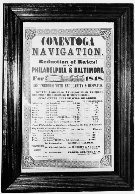
The Conestoga Navigation Company initially built nine locks and dams between Lancaster City and Safe Harbor. The company opened for business in the spring of 1829. Goods shipped on the canal could reach Baltimore weeks ahead of the overland route and with less damages in transit. Business improved each year until an ice flood in the winter of 1832 damaged many of the dams. The business did not recover from the blow. Edward Coleman bought the company at sheriff’s sale in 1833. Coleman rebuilt the locks and reduced the number of dams from nine to seven. After the Susquehanna and Tidewater Canal opened in 1840, Coleman used a crib dam across the Susquehanna to produce enough draught such that canal boats could be towed from the mouth of the Conestoga to an entry port on the canal. The Conestoga Navigation operated until about 1856, when the railroads became the preferred method for transporting freight.
As we can see, Pennsylvania’s waterways served a prominent role in the development of the country. Such use of the waterways came with a cost, however. In the next article in this series, we will look at the Victorian Era, and how the rivers became centers of recreational activities.